GOVERNANCE INFRASTRUCTURE DATABASE DEVELOPMENT
GIS
A geographic information system (GIS) integrates hardware, software, and data for capturing, managing, analyzing, and displaying all forms of geographically referenced information.GIS allows us to view, understand, question, interpret, and visualize data in many ways that reveal relationships, patterns, and trends in the form of maps, globes, reports, and charts.
A GIS helps you answer questions and solve problems by looking at your data in a way that is quickly understood and easily shared.GIS technology can be integrated into any enterprise information system framework. .jpg)
Top Five Benefits of GIS
1.Cost Savings and Increased Efficiency
2.Better Decision Making
3.Improved Communication
4.Better Recordkeeping
5.Managing Geographically
What Can You Do with GIS?
1.Map Where Things Are
2.Map Quantities
3.Map Densities
4.Find What's Inside
5.Find What's Nearby
6.Map Change
Who Uses GIS?
Federal Government
Governments of all sizes use GIS to analyze complex situations and create solutions across disciplines. GIS helps them increase efficiency, reduce costs, improve coordination, and deliver transparency and accountability.
GIS also brings transparency and accountability to federal government by engaging citizens through dynamic, interactive maps.
3.Local Government
4.Homeland Security
5.Military Defense
6.Fire/Emergency Medical Services/Disaster
7.Law Enforcement
8.Health
9.Transportation
State Government
Nearly every govt. departments uses GIS to help meet their missions. Government depends on this technology to bring its vast data into an enlightening geographic context. Departments leverage GIS to increase operational efficiency, track and evaluate activities to meet mandates and support initiatives, and perform analyses that lead to better decision making.
GOVERNANCE INFRASTRUCTURE DB DEVELOPMENT
Governance Infrastructure Database /Spatial Data Infrastructure (SDI)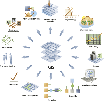
Database form the most valuable part of today's management information system (MIS), & Decision Support System (DSS) A GIS is a unique kind of database of the world. A geographic database (geo-database). Fundamentally, a GIS is based on a structured database that describes the world in Geographic terms. Governance Infrastructure Database will provide a common platform for authorized and secured access to data to harmonize the workflow of respective departments and disseminate information for the public's benefit.GIS Governance Infrastructure database as a solution that brings in greater efficiency by promoting information sharing across multiple departments, speedy decision making, and transparency in the functioning of the government.
WEB GIS Application Development